The Urban Air Project

“The objective of UAP for HiDALGO2 is to achieve a pernode parallel efficiency of at least 80% on multi-GPU and more than 100,000 CPU-core machines for applications with 1 meter spatial resolution, i.e. with a mesh of 60M cells.“
Széchenyi István University (SZE), HiDALGO2-partner from Hungary is developing one of the use cases of the HiDALGO2 project – the Urban Air Project use case (UAP), including several service endpoints: Urban Air Quality (UAP.AQ), Comfort (UAP.Comf),Climate (UAP.Clim), Planning (UAP.Plan) and Reporting (UAP.Rep). The UAP services will provide city operational bodies, policy makers, industry, and researchers of the environment with computational tools that model air quality, wind comfort, and urban planning-related indicators at very high spatial resolution faster than real-time. Thus, for example, the UAP computational tools will allow the users to compute air quality hot spots at 1-2 meter resolution at street level, the maximum wind-speed near tall buildings at the planning phase of the building constructions, and – by assimilating sensor data – create the live simulation of the urban airflow and pollutant concentrations faster than real-time. The solutions require, from the computational side, the development of advanced HPC, mathematical, and AI algorithms and codes, and, on the user side, comfortable web-based user interfaces.
The UAP-team will strongly collaborate with other HiDALGO2-teams, namely with CEMOSIS (Center for Modeling and Simulation in Strasbourg) for coupling their urban building model, the HLRS (High-Performance Computing Center Stuttgart) about urban planning, and MeteoGrid about joint WRF-based weather model and compute the effect of forest fires to city environment.
The UAP use case has two main codes: OpenFOAM and RedSim. OpenFOAM is a world-wide used simulation tool for solving partial differential equations that is proved scalable for large-scale problems. RedSIM is a genuinely multi-GPU and many-CPU CFD-code for unstructured polyhedral meshes that has been developing in the HiDALGO2-project by SZE. RedSIM includes a reduced simulation module for projection-based model order reduction. Based on these two codes, SZE has developed several tools to support the UAP-applications.
In the project both solutions will be developed stepping towards both exascale computing and valuable business solutions.

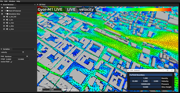
Wind speed and wind direction at 5 meter height from a real-time digital twin for the urban airflow. Sensor data can be modified by hand in the demo mode in the panel of the bottom-right corner.
The service endpoints of UAP
“The UAP works around the evolution of air in urban areas considering pollution, wind, comfort, and planning. The core here is the Urban Air Flow computational model that is massively based on modern HPC, mathematical, and AI technologies.“
Urban Air Project (UAP) integrates several use cases that strongly benefit from the urban wind-field computations of high resolution. UAP.Air, the core of UAP computes urban airflow for cities under 1-5 metre spatial and 1-minute time resolution by considering the 3D building geometries. The simulation domain is exported from OpenStreetMap or provided by the user in the standard STL format, which means that practically there are no limitations of the applications to any European cities. Boundary conditions are derived either from wind measurements or couplings with external weather/wind simulation e.g. those by MeteoGRID. Optionally, wind measurements and/or mesoscale simulation results can be assimilated to increase the accuracy of the wind field simulation. For the quantification of uncertainty of the wind computations, ensemble runs are taken.
UAP.Air as a component is used in UAP.AQ, the air quality computation application, in UAP.Plan, the UAP’s urban planning assisted application, and two direct applications of the wind-field: UAP.Air.Comf the urban air comfort and UAP.Air.Clim the urban air climate computations. The latter two applications compute the Lawson wind comfort as a function of space and time and compute special climate-related quantities like cold flow measures, respectively. In UAP.AQ, the concentration of several pollutants is computed and assessed according to the Ambient Air Quality Directive of the European Commission. To achieve this, emission of the pollutants is either computed in a bottom-up model by considering traffic and building/household emitted emissions or in a top-down way following the methodology of EMEP, the co-operative programme for monitoring and evaluation of the long-range transmission of air pollutants in Europe. Building emissions are computed by using CEMOSIS’ simulation models while the traffic emissions are considered by either traffic simulation and emission computation due to the Copert5 standard model, or the emissions are provided by the user. In UAP.Plan, several goals of the city, and other stakeholders’ objectives are considered and quantified by SZE, and coordinated by HLRS. UAP.Plan utilises the following components: UAP.AQ, UAP.Air.Comf, UAP.Air.Clim.
The aim of the Urban Air Use Case for HiDALGO2

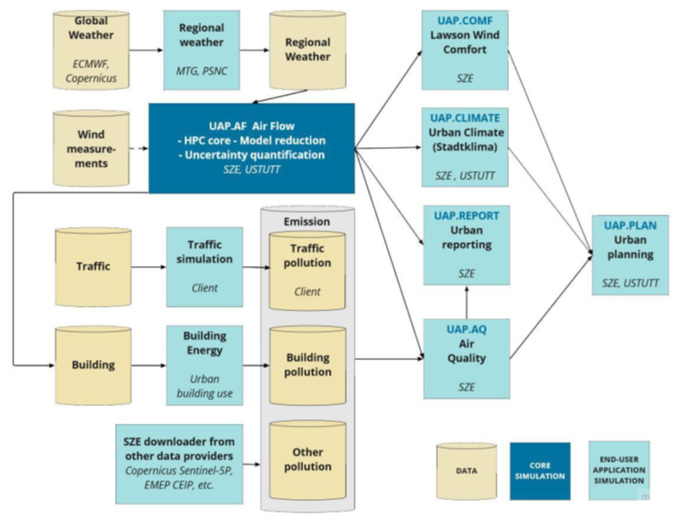
The diagram presents control and data flow for the Urban Air Project use case
The overall aim of this use case for HiDALGO2 is to raise the TRL from 6 to 7, which means creating an operational environment for UAP in which end-users may apply the UAP.AQ features for several cities, including Győr, Illkirch, Poznań, and Stuttgart. For these cities, a reduced order model will be created, too, that enables the users to perform real-time computations of the wind field and air pollutant concentrations. In each application of UAP uncertainties shall be quantified, of which operational implementation will be developed in HiDALGO2. Uncertainty quantification will be conducted using ensemble simulations. UAP.Plan is completely new in HiDALGO2. The aim is to reach pre-exascale performance with UAP.Air and UAP.AQ, whereby two main approaches would most probably require pre-exascale performance:
● Ensemble simulations for uncertainty quantification for UAP.Air and UAP.AQ,
● Training of MOR for UAP.Air, in which a series of full-order simulations for snap-shot matrix generation and then the singular value decomposition of the extremely large snapshot matrix is required.
UAP.AQ is to extend the emission sources very significantly with building/household emissions. To increase the performance of the code, Model Order Reduction (MOR) methods are used particularly in the UAP.AF component. MOR methods are special machine learning methods to train a very fast prediction model based on a series of full simulations. For the easy-to-use feature for policymakers and non-HPC experts, UAP has pre- and post-processing tools including several visualization opportunities and a graphical user interface.
The diagram on the left emphasises the central role of UAP.AF, the urban airflow HPC core module. It requests either a regional weather simulation result or a local wind measurement result. UAP.AF results are used for the urban air comfort computations, the urban climate-related computations, and the urban air quality computations, all coupled to the urban air planning final application. The urban air quality application has the emission module as the main input that couples input from Traffic and building-emitted pollutants. Building emissions will be computed by another use case of the HiDALGO2-project.
Main Algorithms, Tools and Data in the Urban Air Use Case
● OpenFOAM (CFD) Algorithm: solution of time-dependent Navier-Stokes equations for incompressible (OpenFOAM) fluids. OpenFOAM source is open-source, its UAP.Air core is closed, licensed by SZE, and used in the TRL 6-7 products of HiDALGO. Demo access through the portal to this solver is free.
● Fluid-Solver (CFD) Algorithm: solution of time-dependent Navier-Stokes equations for the compressible (Fluid-Solver) fluids. CPU source is open-source, its GPU version is closed, licensed by SZE, and used in the TRL 6-7 products of HiDALGO. Demo access through the portal to the GPU implementation is free. Model order reduction for CFD: Fluid-Solver with the proper orthogonal implementation (POD).
The data used are the city geometry, the road network, and building information data. Global or mesoscale weather data (wind and planetary layer height) is also needed. Emission data for traffic and building emissions (top-down), and traffic data in bottom-up are requested.
