Wildfires

“This use case aims to provide a computational capacity for the simulation of wildfire-atmosphere interactions and smoke dispersion at several scales aimed at the assessment of risk and potential impacts over populated areas“
Meteogrid (MTG), our partner from Spain develops this use case of the HiDALGO2 project – the Wildfires (WF) Use Case. The concern behind the creation of this use case is growing concern over forest fires in Europe and across the world. Recent changing climate conditions make wildfires more energetic, uncontrollable, and destructive, particularly where wildland meets or intermingles with populated areas in the so-called Wildland Urban Interface (WUI).
Forest fire propagation has been modelled for over three decades using several approaches: operational empirical models based upon observation, fast semi-empirical models founded on laboratory research, and sophisticated physical models, including those focusing on fire-fuel and fire-atmosphere interactions. Lately, the production and dispersion of massive amounts of smoke and aerosols from large wildfire conflagrations have also received focus. These physical models require a detailed description of the governing factors, at several scales, and the underlying formulation of the processes, thus involving highly turbulent thermo fluid dynamics, which CFD solvers partially calculate at the expense of high computational resources. These resources are also required for the modelling of lower atmosphere dynamics and the interaction with large fire fronts, particularly the numerical simulation of local winds, the pyro-convective events, and the smoke production and dispersion. These models render separate results which are then partially used for the assessment and mapping of risk and potential impacts of wildfires on the population, infrastructures, and natural environment under different scenarios.
However, just modest progress has been observed over the past few years in the field of model integration under a common, interoperable framework coupling the mentioned phenomena and effects at several scales, partly due to the high volume of CPU resources required to address it. Also, little has been done to transfer such models and results into advanced visualisation platforms (VR, AR) for visual analysis, context training, and risk awareness-raising experiences. These also require the use of dedicated hardware and parallel computing (GPUs).
Landscape and settlement level of the use case

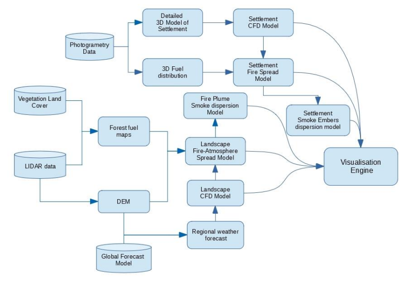
The diagram presents control and data flow for the Wildfires use case
In this use case, we have identified two distinct scales and scenario definitions, which may be of interest: the landscape level and the settlement level (see figure above).
The landscape level aims to provide simulations of wildfire progression, energy release, and coupled atmosphere-fire interactions, particularly the perturbation of wind fields and the generation of pyroconvective movements. Release and dispersion of smoke and incandescent particles (flying embers) are also included.
The settlement level aims to provide simulations of the fire behaviour and flame-low atmosphere interactions, including perturbation of the airflow and the local effect of buildings (hard geometric bodies) and vegetation (fuzzy porous media). Generation, transport, and emissions of flying embers is also considered, as well as the production and dispersion of local smoke. Background smoke due to the general progression of the wildfire is also considered.
As indicated, the simulations of both levels are related and, when needed, coupled (for example, the progression of the flames in the general scale is then analysed in detail in the WUI settlement scale, or the obtained smoke concentrations in the general scale is considered as background smoke in the settlement scale or the expected density of flying embers will be used as a border condition for the detailed simulation of embers flows in the settlement scale.
The aim of the Wildfires Use Case for HiDALGO2
The overall aim of this use case for HiDALGO2 is to provide a computational capacity for the simulation of wildfire-atmosphere interactions and smoke dispersion at several scales aimed at the assessment of risk and potential impacts over populated areas. Integrated models and results in visually-oriented platforms for analysis, training, and education to advance in the understanding and characterisation between fire and atmosphere, in particular the fire-induced wind flow patterns and fire behaviour at mesoscale and microscale in the vicinity and inside of WUI areas.
This will be achieved by coupling weather data and models at different scales, such as mesoscale forecast models (WRF, GFS, ECMWF), numerical fluid-dynamic models of air movement (Open Foam) and smoke emission and dispersion models, with fire spread and fire-atmosphere interaction thermo-fluid-dynamic models (Farsite, Clark, FDS, Firetec).
The models will be adapted, improved, and developed as microservices for their integration as modules in coupled simulations in HIDALGO2 HPC AND BIG DATA TECHNOLOGIES FOR GLOBAL CHALLENGES 25 of 69 interoperable HPC environments and then interpreted visually in immersive and interactive spaces. Some platforms, such as NVIDIA Omniverse, offer such capabilities through the use of standards to ensure integration, interoperability, and rendering of high-end visual environments in a distributed and scalable fashion.
This will help to co-create and maintain digital twins of the populated WUI areas on a case-by-case basis, and test different wildfire scenarios for the improvement of resistance and resilience through the elaboration of good practices guides, regulations, and protocols implemented at local scales. The resulting tools are aimed at a broad type of end users and stakeholders, including local and regional policymakers on civil protection and emergency management, owners and dwellers of WUI areas, and technical staff of municipalities for planning and prevention.
Main Algorithms and Tools in the Wildfires Use Case
The existing ones are:
- Dynamic downscaling such as WRF on weather forecast outputs from global models, such as WRF or ECMWF.
- A two-step analog statistical downscaling model from MeteoGRID/FIC.
- Operational fire spread models, such as Farsite, FireStation, and proprietary code from MeteoGRID (MTG) such as FSIM.
- Physical models of flame-atmosphere interaction, such as Clark, FDS, and Firetec.
- Smoke production and dispersion models in open spaces (CalPuff, Sasem, VSmoke, MLDP Autosim, FireWork, DisperFire) and in urban areas.
- Local fluid dynamics models, such as Open Foam and Ansys Fluent.
- Platforms for the integration and inter-operation of microservices, creation of digital twins and visual simulation spaces, such as Nvidia Omniverse, and game engines such as Unreal Engine 4.
- Algorithms for the real-time visual simulation of static volumetric smoke, such as RayMarching.
- Algorithms and methods for the visual simulation of flames and flying embers, Eulerian-Lagrangian coupled models.
The planned ones are:
- Probabilistic fire spread models in the WUI areas under non-uniform, non-continuous fuel bed.
- Adapted FDS algorithms for the propagation of fire through non-flat, build WUI areas (as follow-up of WFDS and current works of Mell et Al.)
- Algorithms for the visual simulation of animated volumetric smoke, i.e. using compression techniques of 3D textures and packing them into MP4 and other video formats.
The following data was identified as required to conduct research:
- High-resolution mdt, lidar data, and photogrammetry imagery.
- ECMWF and GFS forecast data.
- Meteorological observations.
